Two days at JBay – July 3/4

Surfers know how it is. There are some places you want to go. Like Pipeline in Hawaii, G-land in Indo. And Jeffries Bay, or JBay as it is known, is one of them. We woke up to a perfect winter’s day, barely a breeze to be had, not a cloud in sight, and about 20 degrees. We had breakfast looking out over the Indian Ocean and watched a group of whales cruising by.
Supertubes is the famous break here, and we are staying about 200m from it. So John organised a hire board (being the only surfing accessory he couldn’t fit in his bag), and disappeared for some fun. He reports that it was poor to medium, but easy to see how good it could get.
Ferg and Harry had a great morning on the beach in the sun.
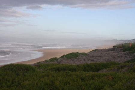
A quiet afternoon, where John squeezed in another solo surf, then took the boys out for a quick dip. Here’s a pic I took of the boys at the water’s edge, while John gets a last wave and the moon rises. Sweet.

20120704-171350.jpg
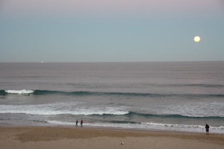
And that’s a squid boat on the horizon – the first of many each night. We used to see them from our house back home when we first moved there in the mid 90s, not for some years now.

The Fourth of July brought a change to the weather. A howling southwesterly and buckets of rain with it. Although the wind was favorable for another surf, the swell was in a coma. If there’s one thing I’ve learnt about surfing, it’s that you need a big weather window to guarantee a good time. So our brief two days didn’t really deliver. Maybe come back another day? Might be best to leave town as they are setting up for the Billabong Pro comp which starts in a few days. The circus is in town.

We headed south for a look at St. Francis Bay where is was getting windier and the downpour continued. This is the most amazing town. There are two sections and in one part, every single house, without exception, is white with either a slate or a thatched roof. It’s an unwritten law.

20120704-172404.jpg
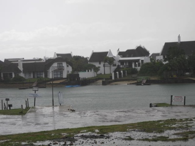
The other part of town is all beige. Clearly they don’t make the most of their non-white opportunity. Very beige.

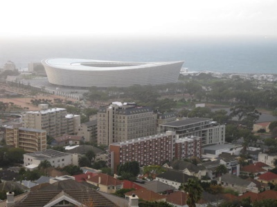
Here’s a random photo of the stadium they built for the Soccer World Cup in Cape Town.

20120704-172602.jpg
Leaving South Africa tomorrow for the Zambian side of Victoria Falls.

Knysna and no Internet – July 2

It’s sad to think I’m actually disappointed that we had no Internet last night. How times change. I remember travelling through Europe, Canada and the US in the early 80s when we used a Poste Restante to collect snail mail every month or two. A long distance phone call was a big deal, and we used film cameras and waited till we had enough money to develop the pics. Now, we travel with a power board to charge the iPhones, the iPad, my two digital cameras (one SLR and one snappy job), the boys’ cameras, John’s GPS/watch, …..I think that’s all. Our photos are reviewed instantly, and (Internet reception pending) we are in contact with the whole world all the time.

Today we moved along the coast to Knysna, another enormous town/city. I’m starting wonder if South Africa has anything like Wye River on the books, with a pub, a shop and a camping ground. John offered me the opportunity to have a “La de da Latte” at a swish little cafe at the heads to the inlet on which Knynsa sits. It really was a good brew, and indeed we were surrounded by the beautiful people that own the insanely expensive real estate splashed all over the hill sides. As John says, “no holiday shacks here”, only mansions.

On to the Elephant Sanctuary – a place that looks after elephants that have been injured and orphaned due to poaching. We got to touch and walk with the elephants, – they have very snotty noses – but declined to ride them. I really don’t think they were meant for that.

Right next door was a huge bird sanctuary. We saw some beautiful birds, including toucans, macaws and heaps that we don’t know the names of! Just look forward to a Slide night at our house and you’ll get to see them all!
From there it was a couple of hours drive to Jeffries Bay where we will be for a two nights. John has a board lined up and the sharks are circling awaiting his entry into the famed breaks here.

20120703-142048.jpg

Here’s Harry and me up close and personal with one of the elephants.

20120703-142131.jpg

The charging fiasco.

20120703-142114.jpg

One of the Toucans. They are much smaller than I thought they would be.

20120703-141740.jpg

Ferg walking with a snotty nosed elephant. It was cool.

Ostrich Day – July 1

We spent last night in the Mooiplaas Guest House, and after scrambled ostrich egg for breakfast, we headed up a beautiful (although rather touristy) valley to the Cango Caves. Can’t say they topped my 35 year old memory of the Jenolan Caves in the Blue Mountains that I visited with mum and dad. The boys were impressed though, and I’m sure had images of dragons and the like living in there.
Onto the ostrich farm. This valley gets to over 40 degrees in the summer and suits the breeding of ostriches. They use the meat (delicious), the eggs (one is the same as 24 chicken eggs), the feathers, and the leather. I refrained from buying a gorgeous ostrich leather handbag for $1000. I don’t think there are any poor ostrich farmers.
Ferg and Harry both had a ride on an ostrich and, not surprisingly, was the highlight of their day.

Along the way in this region you can smell Camphor Trees from time to time. Never smelt that in nature before – apart from in the pharmacy!

Over the mountains at 840m elevation, and down to the coast at Mossel Bay. We thought this would be a quiet little town, but it’s actually over 50,000 population. A huge sprawling city, with the obligatory “township” adjacent. Some cultures refer to these townships as slums, but they are really just a different standard of housing (that was an understatement) with increasing organisation of electricity supply and maybe one day sewerage too.

We drove east to a small area called Glentana, and stayed in a guest house right on the beach and fell asleep listening to the Indian Ocean pound the shore line.

20120703-140915.jpg
Harry having a ride on an ostrich.

20120703-141125.jpg
Beach at Glentana – very similar to Johanna or Station Beach down in the Otways

A day on the road – June 30

Ferg, Harry and John started today with a 3km run to a really cool playground next to the funky stadium they built for the soccer world champs. It has climbing stuff, ropes activities and spinning thing…..all for 7-16 year olds. A run home and a big breakfast before hitting the road for Oudtshoorn – about 500km – east along the Garden Route. The landscape varied from rolling green hillsides as far as you can see, reminding us of mid north South Australia, to craggy treeless peaks just like the Pyrnees or even New Zealand. Then it became dry and scrubby, and we were convinced we could be in the Australian outback with red dirt that could have put us in the beautiful Red Centre.
We are staying on a guest farm just out of town, and have enjoyed a delicious dinner of medium rare ostrich. The boys loved it too!
John has Man Flu (read – just a cold) and is only just coping with being away from home for the Tour de France coverage. It’s hard to see it live when we’re out and about all day! Needless to say, it’s the first thing checked (before email) when we get Internet connections. Although it might just slip down the list when we get to Jeffries Bay and he wants to see what the surf is like.

Baboons are everywhere:

20120630-214137.jpg
and can be dangerous. We saw them down near the Cape, and today on a spectacular mountain pass on the way to Barrymore. They just hang about by the road side. Far more intelligent than, say, our kangaroos though. The baboons move out the way of the cars!

Cape of Good Hope – June 29

Here’s a random photo of us all on Table Mountain. Nothing to do with today’s fun.

20120629-201028.jpg
And so, to today……. There are some places you have to go (Pyramids of Egypt, Eiffel Tower, Grand Canyon – stuff like that) and the Cape of Good Hope is one. The most south westerly point in the continent of Africa (most southern point is Point Agula – about 200km east from here) is somewhere that travellers like to go. It has a great name, it has history, and it is spectacular.
We left Cape Town this morning and travelled by car with a local guide along the eastern side of the Cape. The whole region has many historic buildings due to its Dutch and English colonisation, not to mention the Portuguese influence. We saw some beautiful old buildings from centuries ago, especially at Simon’s Town. Here we visited a penguin colony where there is now a population of over 3000 birds, which was nurtured from just one pair some years ago.

20120629-202534.jpg
The landscape is wind blown and treeless, reminiscent of Scotland. The vegetation of local wildflowers and shrubs was lush with winter rains, and whilst we didn’t see any zebras, there were quite a few antelopes (can’t remember their correct name) and ostriches wanderings around.
So we made it to the fabled Cape of Good Hope –

20120629-203323.jpg
Unreal! It was really windy there, making for a bad hair day. We walked up to the point (didn’t get blown off) and then across to Cape Point where the light houses are. The first one they built was too high and got lost in the fog too often, so they built one down lower at 87m above the sea.

20120630-083659.jpg
This is looking back to the Cape of Good Hope from the lighthouse. We drove back along the Atlantic coast of the Cape to have a late lunch in Hout Bay. The road here cuts into the cliff side and puts the Great Ocean Road to shame. Can you believe I said that? It was spectacular.
Leaving Cape Town tomorrow, and driving east for a few days.
Gee, and I thought I’d write a short paragraph at the end of each day!